


The Fourth of July weekend will bring a messy mix of heat, humidity, scattered thunderstorms and a growing heavy rain risk across the Finger Lakes, with the most active weather expected Saturday afternoon and again early next week.
 New York Heat Wave Breaks Nighttime Temperature Record as Extreme Heat Continues Across the City
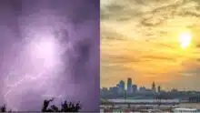
 Forecasters say the region is moving out of the worst of the recent heat wave, but not before one more round of muggy, stormy weather creates issues for outdoor plans, boating, travel and fireworks events.

Saturday brings storm risk after humid start
The National Weather Service says showers and scattered thunderstorms will develop again Saturday, with the best coverage expected during the afternoon and early evening.
The setup is familiar for midsummer in Upstate New York. A weak frontal boundary is sliding south through the region while warm, humid air remains in place. That combination will allow showers and thunderstorms to fire up as the day heats up.
The severe weather risk is not expected to be widespread, but forecasters say a few storms could become strong to severe, especially across the Southern Tier and Finger Lakes. The main concern will be locally strong wind gusts, though hail cannot be ruled out in stronger storms.
Any storm could also produce brief heavy rain, reduced visibility and quick changes in conditions. That matters for holiday travel, lake activity and outdoor gatherings, especially during the afternoon and evening window.
The good news is that storms should weaken after sunset as daytime heating fades. That could help some fireworks displays and evening events, though timing will vary by location.
Heat eases, but humidity lingers
The worst of the heat wave is behind the region, according to the National Weather Service in Buffalo, but Saturday will still feel humid.
Highs across much of the Finger Lakes should reach the low to mid 80s, with dew points still high enough to make the air feel sticky. Cloud cover and showers will keep temperatures lower than recent days, but the air will remain uncomfortable at times.
Forecasters in Binghamton noted that temperatures will depend heavily on storm coverage and cloud cover. Areas that see more sun before storms develop could warm faster and become more unstable.
That is part of the reason Saturday’s thunderstorm forecast carries some uncertainty. Breaks in the clouds could allow storms to become stronger, while thicker cloud cover could limit instability.
Either way, the region should begin a gradual step down from the recent stretch of dangerous heat. Temperatures and humidity will trend closer to typical midsummer levels by Sunday and early next week.
 Flash Flood Warning Issued for Hammond Tinley Park and Calumet City What Residents Should Expect
 Sunday and Monday look unsettled
The holiday weekend will not turn fully dry after Saturday.
A weak low pressure system is expected to develop over Ohio on Sunday before drifting east toward the Mid-Atlantic on Monday. At the same time, deeper moisture will remain close to the Southern Tier and Pennsylvania border, keeping showers and a few thunderstorms in the forecast.
Rain chances will be highest across the southern half of the region, including parts of the Southern Tier, Tompkins County, Schuyler County, Steuben County and nearby areas. Locations farther north, especially closer to the Thruway and Lake Ontario, may see lower rain coverage.
That northern edge remains one of the biggest forecast questions. A sharper push of dry air from Ontario and Quebec could keep some areas mainly dry, while a farther-north storm track would spread more rain into the Finger Lakes.
Sunday and Monday will not be washouts everywhere, but the pattern favors occasional showers, cloudy periods and a few thunderstorms. Outdoor plans should include backup options, especially south of the Thruway.
Heavy rain risk grows early next week
The bigger concern comes late Sunday into early Tuesday, when moisture overruns the front and low pressure passes south of the region.
Forecasters say the atmosphere could hold unusually high moisture for early July, with precipitable water values approaching 2 inches. That means any showers or storms that develop could produce efficient rainfall and locally heavy downpours.
Most forecast guidance points to around an inch of rain for many areas, but some ensemble data suggests localized pockets could see much higher totals if heavier bands set up repeatedly over the same locations. The Binghamton forecast discussion noted that some European model ensemble members show isolated 3- to 5-inch rainfall potential, though other guidance is less aggressive.
That does not mean everyone will see flooding rain. It does mean the early-week forecast deserves attention, especially in areas with poor drainage, steep terrain, small streams or spots that already picked up rain from recent storms.
Clouds and rain will also hold temperatures down early next week. Highs will likely run cooler than previous forecasts suggested, with many areas staying closer to seasonable or slightly below-seasonable levels depending on rainfall coverage.
By Tuesday, the unsettled pattern may still support a few scattered showers or isolated thunderstorms, mainly inland from the lakes. Drier weather should become more likely by Wednesday as high pressure builds toward the eastern Great Lakes.
For now, the practical message is straightforward: Saturday brings the main holiday storm risk, Sunday and Monday stay unsettled, and early next week could bring locally heavy rainfall if the wetter setup verifies.
FingerLakes1.com is the region’s leading all-digital news publication. The company was founded in 1998 and has been keeping residents informed for more than two decades. Have a lead? Send it to news@fingerlakes1.com.