


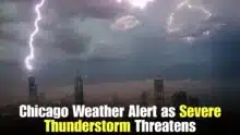
Heavy rain has prompted emergency weather experts to issue a flash flood warning for parts of northwest Indiana and the south suburbs of Chicago, raising fears of fast-rising water levels on highways, neighborhoods and low-lying regions. Hammond, Tinley Park and Calumet City are other communities in the vicinity that could experience periods of severe rain that could lead to flooding of drainage systems in a short amount of time. “Residents are reminded to be alert to changing conditions, especially during the evening and overnight hours when waters on the roads may be hard to see.”
 New York Heat Wave Breaks Nighttime Temperature Record as Extreme Heat Continues Across the City
 Hammond, Tinley Park and Calumet City Flash Flood Warning issued as forecasters continue to monitor slow-moving thunderstorms capable of producing substantial rainfall. Officials are warning anyone living near streams, rivers and flood-prone neighborhoods to stay tuned to local weather updates and avoid unnecessary travel until the threat has passed. Even a small amount of moving floodwater can be hazardous to both autos and walkers.
Flash Flood Advisory for Hammond, Tinley Park, Calumet City
The warning came from weather experts when radar detected thunderstorms with heavy rain heading through the area. Heavy rain rates could be enough to overwhelm storm drain capacity and cause water to build up quickly in streets, underpasses and parking lots. Flash flooding can happen in a matter of minutes and offer little time for homeowners to prepare.
The advisory mentions several sites where the major risk is urban flooding. Small creeks, poorly drained places and low-lying roads are most at risk. Emergency managers are telling people to stay inside as much as they can and be ready for short-term traffic disruptions.
Heavy rain can cause flash floods.
Multiple rounds of thunderstorms will move across the same locations, increasing the possibility for localized flooding. Heavy rain can overwhelm drainage, leading to rapidly rising water levels and hazardous conditions.
Never attempt to drive through a flooded road, as you will not be able to see the level of the water. Floodwater can also conceal defective pavement, open drains or debris which might suddenly trap autos. People should also remain off flooded sidewalks and outside crossings.
Most at-risk areas during warning
This is especially true for urban communities, where vast expanses of concrete and asphalt prevent rainwater from soaking into the soil. Streets and neighborhoods can soon fill up with runoff.

People who reside close to:
- Roads at grade
- Brooks and little streams
- Underpasses
- Poorly drained areas
- Foundation and Basement Water Intrusion
must take special caution. If conditions worsen, local officials may temporarily close flooded highways.
Safety Tips for Residents
Emergency management officials are urging all those in the alert area to take simple precautions before and during the storm.
- Drive only if you must.
- Do not walk or drive in floodwater.
- Charge your cell phones.
- Check for dependable weather updates and emergency notifications.
- If there is a chance of flooding, move valuables off of basement floors.
- Severe storms could trigger brief power outages. Be advised.
These procedures will go a long way toward reducing the possibilities of getting hurt when the weather changes quickly.
What Happens Now?
Meteorologists will continue to monitor rain totals and storm movement during the warning period. If these thunderstorms slow down or we get more heavy rain, the potential of flash flooding could persist longer than we predicted. Weather conditions may change, and updated warnings or advisories may be issued.
Akash Negi focuses on weather coverage that helps readers stay prepared, from daily forecasts and seasonal changes to storm alerts, temperature shifts, and weather-related updates. His reporting provides clear and timely information for people planning their day, travel, and local activities.