


Weather is becoming a big issue for millions of people preparing to enjoy Independence Day in the Kansas City area. Forecasters are warning that a mix of high summer heat, rising humidity, and the potential for strong thunderstorms might impact outdoor events during the holiday. Most of the day is anticipated to be warm and partly sunny, but changing conditions later in the afternoon and evening may bring heavy rain, strong winds, and severe lightning to sections of the area. Those intending to head out for fireworks shows, barbecues, or neighborhood parties should keep a close watch on the current weather.
 New York Heat Wave Breaks Nighttime Temperature Record as Extreme Heat Continues Across the City
 Weather Update for Kansas City
The Kansas City Weather Update shows a warmer and increasingly unsettled weather pattern on July Fourth. Afternoon highs will be in the lower 90s, but with high humidity values, it may feel much warmer with heat-index values near or above 100 degrees in some spots. Scattered thunderstorms are also expected to occur later in the day when a cold front approaches the area, meteorologists said. Not all neighborhoods will experience storms, but when storms do develop, brief, heavy rain, frequent lightning, and severe wind gusts will be possible.
Dangerous Heat Continues Through Afternoon
The first half of the holiday will be dominated by heat as the greatest weather concern. Temperatures will be much above normal, especially in the afternoon hours when the sun is the fiercest. Add the humidity to that heat, and it may become uncomfortable and even life-threatening for those who are outside for long hours.
Health officials are advising people to drink plenty of water, take frequent rests in the shade or in air-conditioned buildings, and wear light clothing. Children, older adults, and people with chronic health concerns are particularly sensitive to heat-related illnesses. Pet owners can also make sure animals have access to fresh water and cooler areas during the day.
Chance of Storms Rises Before Evening Festivities
Weather models indicate a weather system moving toward eastern Kansas and western Missouri that will make the atmosphere more unstable later this afternoon. There is a chance of isolated thunderstorms before or during the evening fireworks.
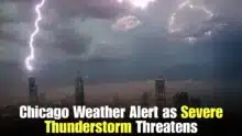
 Flash Flood Warning Issued for Hammond Tinley Park and Calumet City What Residents Should Expect
 Some storms may strengthen enough to cause damaging wind gusts, torrential downpours, and hazardous cloud-to-ground lightning. Localized flooding is also possible where heavy rain develops. Storm coverage will likely be hit-or-miss, with some areas staying dry while others encounter conditions changing quickly.
Fireworks Plans Could Be Impacted
Many Independence Day activities in the Kansas City area are planned to begin after dusk. Storm chances will stay in the forecast; however, temperatures will progressively cool through the evening.
Event organizers will likely watch the radar closely before setting off fireworks. Lightning is one of the biggest safety risks at outdoor events, even if the rain is minimal. Visitors should be aware of the location of local shelters before coming to festivals and be prepared to evacuate open areas immediately if they hear thunder.
Looking Ahead After the Holidays
That weather pattern is forecast to be a bit less strong after the Fourth of July when the oncoming front goes across the region. Temperatures may trend a bit more toward seasonal averages, while sporadic showers and thunderstorms may linger into the weekend.
Temperatures might be a little lower, but homeowners should still be weather conscious as July storms can develop quickly.
Akash Negi focuses on weather coverage that helps readers stay prepared, from daily forecasts and seasonal changes to storm alerts, temperature shifts, and weather-related updates. His reporting provides clear and timely information for people planning their day, travel, and local activities.