


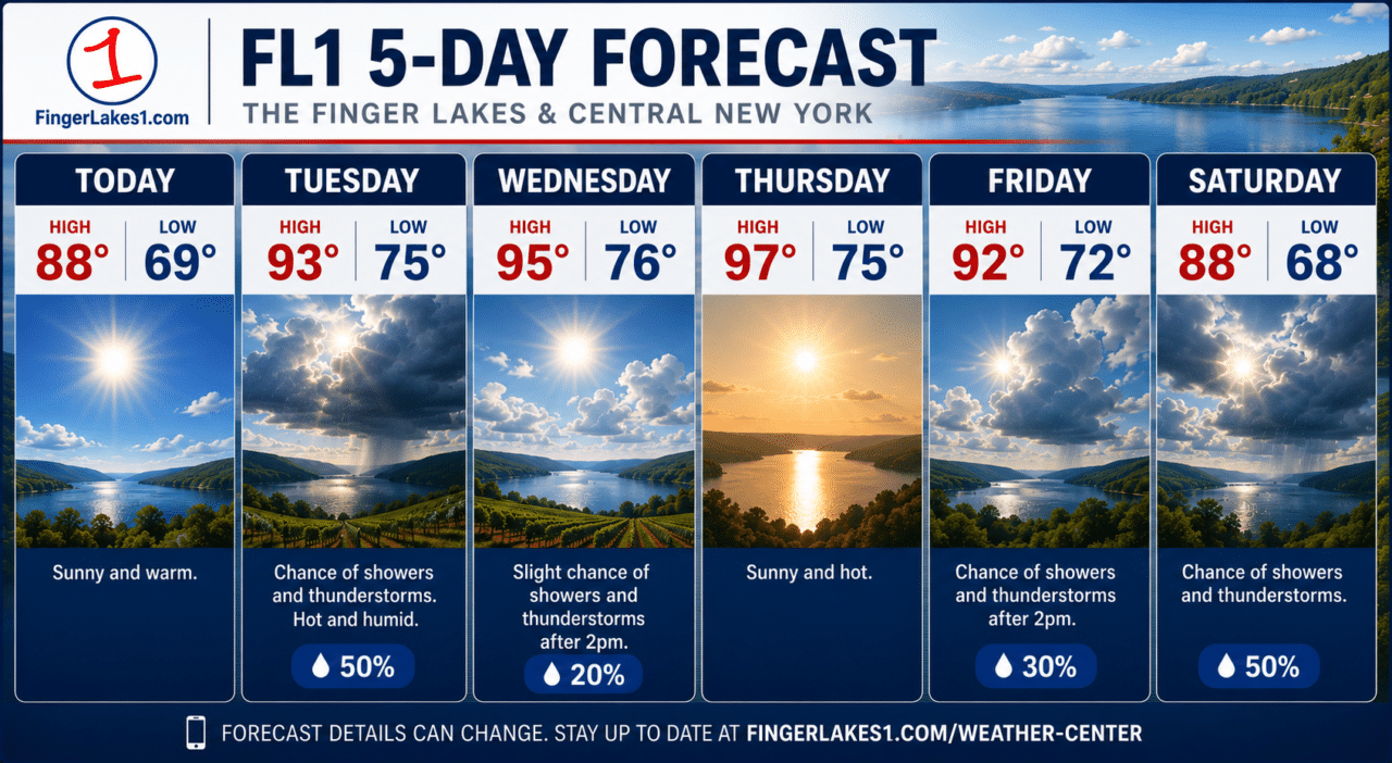
A Heat Advisory takes effect Tuesday afternoon across much of the Finger Lakes and Central New York, and forecasters are already warning that even more dangerous conditions could follow later this week.
 Louisiana Meteor Fireball Lights Up the Early Morning Sky Across the Southern United States
 The National Weather Service has expanded heat headlines across the region, with a Heat Advisory in effect Tuesday and an Extreme Heat Watch posted for Wednesday through Friday as temperatures climb into the 90s and humidity pushes heat index values toward — and in some places above — 100 degrees. Some urban valley locations could briefly approach 105-degree heat index values if sunshine dominates.
This will be the hottest weather of the summer so far, but the heat won’t be the only concern. The same atmosphere fueling the dangerous temperatures will also support daily chances for thunderstorms, some capable of producing damaging wind gusts, torrential rainfall, and localized flash flooding.
Today’s weather

Monday serves as the calm before the heat.
Sunshine will dominate after any early morning valley fog dissipates, with afternoon temperatures climbing into the middle and upper 80s across the Finger Lakes, Rochester, Syracuse, Auburn, Geneva, Canandaigua, and Ithaca. Humidity will begin increasing later today, but conditions will remain noticeably more comfortable than they will be by Tuesday afternoon.
Clouds will increase tonight as a warm front approaches from the west. A few showers or thunderstorms may develop overnight into Tuesday morning, although many locations will remain dry until later in the day.
Heat advisory begins Tuesday
The weather pattern undergoes a dramatic change Tuesday as a sprawling heat dome strengthens over the eastern United States.
This large area of high pressure acts like a lid on the atmosphere, trapping heat and moisture near the ground while allowing temperatures to build each afternoon. Southwesterly winds will continue transporting Gulf moisture northward, driving dew points into the lower and middle 70s and making the air feel exceptionally oppressive.
Tuesday afternoon’s Heat Advisory covers much of the Finger Lakes, including Ontario, Wayne, Yates, Seneca, Cayuga, Tompkins, Schuyler, Steuben, and surrounding counties. Heat index values are expected to range from the upper 90s to around 100 degrees, making prolonged outdoor activity potentially dangerous.
Conditions are expected to become even more hazardous Wednesday through Friday. An Extreme Heat Watch has already been issued because forecasters believe portions of the region could briefly reach heat index values near 105 degrees if clouds and thunderstorms don’t interrupt daytime heating. Overnight lows in the middle 70s will provide very little relief, increasing stress on people without reliable air conditioning.
Forecast confidence remains high that dangerous heat will develop. The biggest uncertainty involves exactly how hot temperatures become each afternoon because scattered thunderstorms may limit heating in some communities.

Thunderstorms remain part of the forecast
Unlike many prolonged heat waves, this one won’t be completely dry.

The Finger Lakes will remain near the northern edge of the upper-level ridge, allowing disturbances to ride around its perimeter. That setup creates daily opportunities for afternoon and evening thunderstorms from Tuesday through at least Friday.
Tuesday currently appears to offer the greatest severe weather potential. Forecast models show exceptional atmospheric instability, with enough energy to support strong thunderstorms if they can develop. Forecasters are also watching for the possibility of a larger thunderstorm complex moving into the Northeast, although confidence in the exact timing and location remains low.
Any storm that forms this week will be capable of producing intense rainfall rates, isolated damaging wind gusts, and dangerous lightning. Because winds aloft will remain relatively light, some storms could repeatedly track over the same locations, increasing the risk of localized flash flooding.
Staying safe during dangerous heat
This week’s forecast is about more than uncomfortable weather.
Health experts recommend drinking water throughout the day, limiting strenuous outdoor activity during the hottest afternoon hours, wearing lightweight clothing, and spending as much time as possible in air-conditioned buildings. If you work outdoors, take frequent breaks in shaded areas and avoid pushing through symptoms of heat illness.
Know the warning signs of heat exhaustion, including heavy sweating, dizziness, weakness, muscle cramps, headache, nausea, and excessive thirst. If someone develops confusion, loses consciousness, stops sweating despite extreme heat, or has hot, dry skin, treat it as heat stroke and call 911 immediately.
Never leave children or pets inside parked vehicles. Even with windows cracked, vehicle interiors can become deadly within minutes during this type of heat event.
Looking ahead
The hottest conditions are expected Wednesday and Thursday before subtle changes begin arriving late in the week.
As the upper-level ridge weakens and shifts southward heading into the Independence Day weekend, shower and thunderstorm chances will increase while temperatures gradually ease. It will remain warm and humid through the holiday, but the extreme heat should slowly lose its grip as a cold front approaches from Canada.

Until then, the Finger Lakes is entering a stretch of weather that deserves close attention. With dangerous heat during the day, warm nights that offer little recovery, and scattered thunderstorms capable of becoming strong, residents should plan outdoor activities carefully and stay alert to changing forecasts over the next several days.
FingerLakes1.com is the region’s leading all-digital news publication. The company was founded in 1998 and has been keeping residents informed for more than two decades. Have a lead? Send it to news@fingerlakes1.com.