


As a powerful and dynamic weather pattern takes shape throughout North America, focus shifts to a significant heat setup anticipated to develop over the Western United States in the coming week. Forecasters are monitoring a large high-pressure system that might combine with seasonal monsoon rainfall in the South and Southwest to drive temperatures well above normal. This combination could bring a tricky, possibly tumultuous weather shift, with some places experiencing extreme heat and isolated thunderstorms developing in others. In numerous areas, residents are being warned to stay alert as conditions can change rapidly.
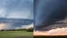 Southern Ontario Storm Warning Damaging Weather System Could Bring Tornado Risk on Thursday
 Heat Dome Moving to Western U.S. Next Week
The pattern is forecast to bring above-normal temperatures to sections of California, Nevada, Arizona, and surrounding areas. Meanwhile, the North American Monsoon has begun to pull precipitation from the Gulf of California and the Gulf of Mexico into the Southern Rockies and drought-stricken Southwest. As dry heat clashes with incoming tropical moisture, there could be drastic swings in weather conditions over very short distances.
High-Pressure Systems to Western U.S.
A heat dome is a high-pressure system that sits over an area like a lid on a pot, trapping the heat underneath it. The system is forecast to strengthen and remain over the Western U.S. for several days. Temperatures may continue to rise during the day with little relief overnight. Inland cities in California, Nevada, and parts of Arizona, particularly urban areas with high heat retention, could be susceptible to sustained heat stress.
Simultaneously, the building ridge could help push monsoon storms even farther to the north and east, raising the threat of isolated but powerful thunderstorms. It’s a double whammy — severe heat in some spots and quickly building storm activity in others. These patterns are not rare in midsummer, but their intensity and timing can have a huge impact on daily life, farming, and energy use.
 New York City Extreme Heat Warning Issued Through July 4 Weekend Here's What Residents Should Know
 North American Monsoon Moisture Outbreak
This moisture can also help trigger afternoon and evening thunderstorms, especially over the higher terrain of the Arizona mountains and New Mexico’s high desert country. These storms can form swiftly and may bring heavy rain, lightning, and isolated flash flooding.
“When you throw in the interaction with the heat dome, things get a lot more complicated. One mechanism is the sinking of dry air and high heat. The other allows moisture to rise and form storms. As conditions change rapidly, visitors and outdoor workers may need to continually adjust their plans.”
Safety Concerns and Regional Impacts
If the predicted intensification of the heat dome comes to fruition, many days of unrelenting high temperatures could be in store for the Western United States. It raises the specter of heat-related illnesses, ramped-up electrical demand, and stress on water supplies.

Final Thought
The North American Monsoon will continue to pump moisture and spark scattered thunderstorms over the Southwest, but the heat dome building over the area may deliver a hot stretch for several states. This overlapping pattern produces a blended forecast that accounts for excessive heat concerns and rapid storm activity.
Akash Negi focuses on weather coverage that helps readers stay prepared, from daily forecasts and seasonal changes to storm alerts, temperature shifts, and weather-related updates. His reporting provides clear and timely information for people planning their day, travel, and local activities.