

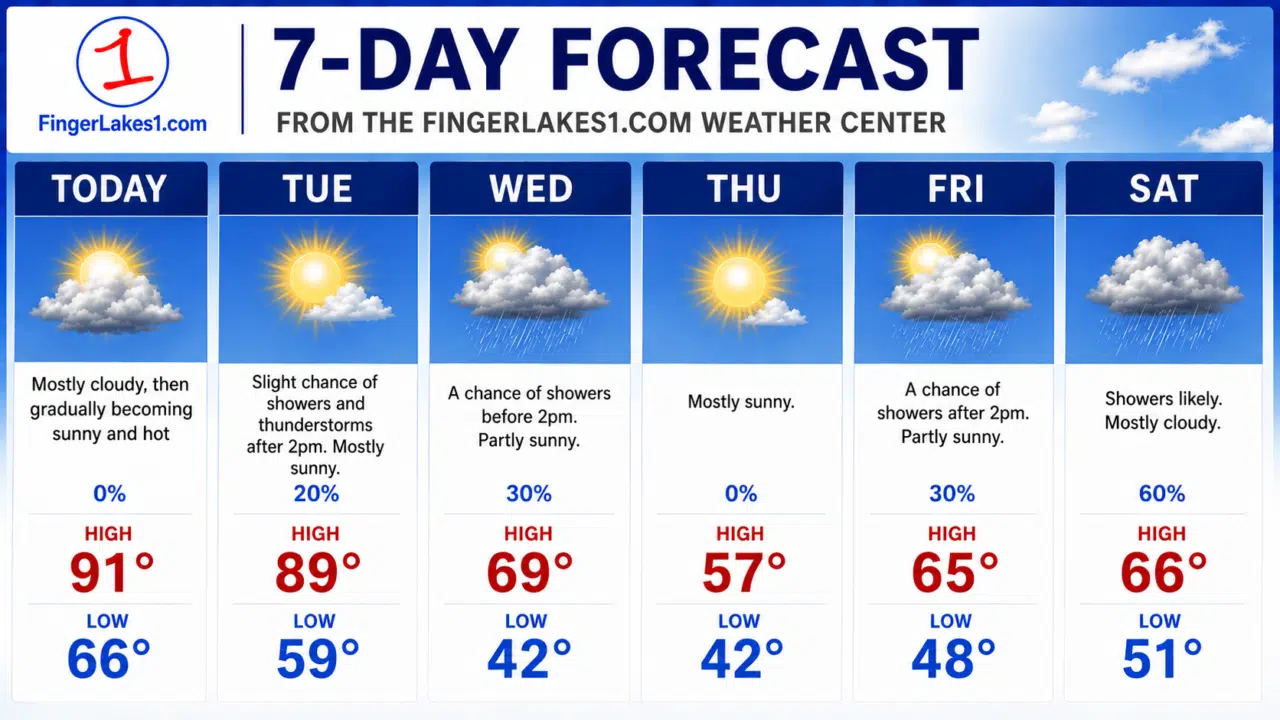
The Finger Lakes is getting its first real taste of summer this week, with temperatures expected to surge into the upper 80s and low 90s before strong thunderstorms and a dramatic cooldown arrive by midweek.
Forecasters with the National Weather Service say a strengthening ridge of high pressure stretching north from the Southeast will push warm, humid air into New York through Tuesday, creating conditions more typical of July than mid-May.
Monday and Tuesday are expected to be the hottest days, with inland parts of the Finger Lakes potentially approaching 90 degrees. Areas near the lakeshores will likely stay slightly cooler due to cold lake water temperatures, but much of the region will still experience unusually warm weather for this time of year.
Humidity will also climb steadily through Tuesday, with dew points rising into the 60s and making conditions feel increasingly muggy.
Forecasters say a few isolated showers or thunderstorms could develop during the afternoon and evening hours Monday and Tuesday, though widespread rain is not expected early in the week. If storms are able to develop, atmospheric conditions could support isolated severe weather, including gusty winds.
The more significant weather threat arrives late Tuesday into Wednesday as a strong cold front pushes into the region.
Meteorologists say showers and thunderstorms are expected to become more widespread Tuesday night through Wednesday morning, with some storms potentially turning severe. Damaging wind gusts are considered the primary threat, though forecasters say large hail and even an isolated tornado cannot be ruled out.
The Storm Prediction Center has already outlined much of western and central New York in a slight risk area for severe weather Tuesday night.
The timing of the front could also create a sharp temperature divide across the region Wednesday. Forecasters say parts of the Finger Lakes may struggle to get out of the upper 60s or low 70s Wednesday while areas farther southeast remain in the 80s before the front fully clears the region.
Behind the front, the weather pattern changes quickly.
Much cooler and drier air is expected to settle into the Finger Lakes for the second half of the week, with highs dropping back into the 50s and 60s by Thursday and Friday. Thursday is currently shaping up to be the coolest day of the stretch, with some locations potentially failing to escape the 50s.
The cooler pattern is expected to hold into at least the start of Memorial Day weekend, though forecasters say another unsettled weather system could approach by late weekend.
Breezy conditions are also expected at times through Tuesday, especially across areas east and northeast of the Finger Lakes, where wind gusts could approach 30 mph.
Boaters on Lake Ontario may also encounter rougher conditions Tuesday into Wednesday as winds and waves increase ahead of the cold front.
FingerLakes1.com is the region’s leading all-digital news publication. The company was founded in 1998 and has been keeping residents informed for more than two decades. Have a lead? Send it to [email protected].