New York’s fall could begin with stretches that feel more like an extension of summer before gradually turning cooler, with long-range forecasts pointing toward above-normal temperatures for much of the season, somewhat drier conditions overall and the potential for the first meaningful snow by late October or November.

The biggest driver is a strengthening El Niño in the tropical Pacific. NOAA’s Climate Prediction Center says there’s a greater than 90% chance the event becomes very strong during the fall and winter, while AccuWeather forecasters say it could become one of the strongest on record.

For New York, that doesn’t mean every week will be unusually warm or dry. Seasonal outlooks describe broad tendencies over three months, and short-term cold shots, rainstorms and even early snow can still occur.
But taken together, the forecasts point toward a relatively mild start to autumn, a delayed transition toward persistent chill and a pattern that may favor somewhat less precipitation than normal across parts of the Northeast.
September could stay mild, but not uniformly warm
NOAA’s updated September outlook is less aggressive about warmth in the Northeast than some earlier forecasts.
The Climate Prediction Center puts much of the Northeast in the “equal chances” category for September temperatures, meaning there isn’t a strong enough signal to favor above-, near- or below-normal temperatures for the month as a whole.
That uncertainty is being driven in part by the potential for troughing — dips in the jet stream that can bring cooler air into the Northeast.
At the same time, NOAA favors above-normal precipitation during September across the eastern Great Lakes and much of the Northeast.
So while September may feature warm stretches, especially between fronts, New Yorkers shouldn’t expect an uninterrupted continuation of summer.
AccuWeather’s seasonal forecast takes a broader view and says it may take until October before more substantial intrusions of chilly air reach the Great Lakes and Northeast.
Even then, forecasters don’t expect those early cold outbreaks to necessarily last.
That could produce the familiar early-fall pattern of warm afternoons interrupted by brief shots of noticeably cooler weather rather than an immediate transition into sustained autumn cold.
The full fall season tilts warmer than normal
The signal becomes clearer when September, October and November are considered together.
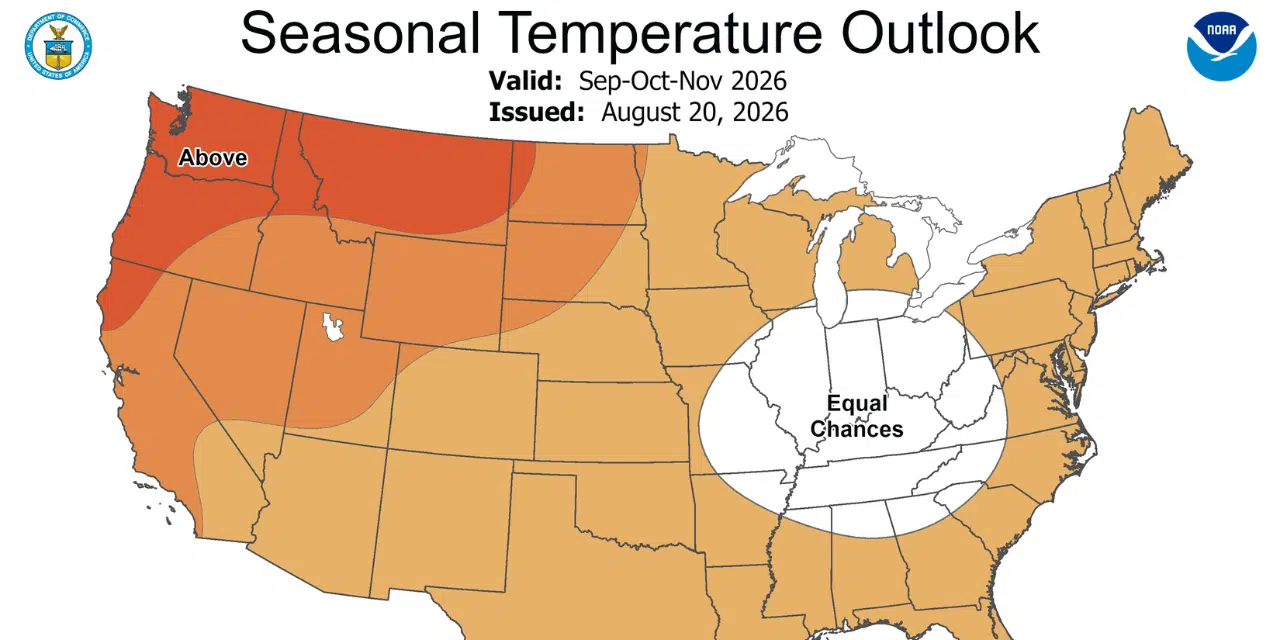
NOAA’s fall outlook favors above-normal temperatures across the Great Lakes, Northeast and Mid-Atlantic.
That means New York has a better chance of finishing meteorological fall — September through November — warmer than the 1991-2020 average.
A warmer seasonal average doesn’t mean every month will be warm. A few sharp cold spells can still occur while the overall three-month period ends above normal.
NOAA notes that fall temperature patterns during strong El Niño events can vary considerably, which lowers confidence compared with winter forecasts. Recent long-term warming trends are one reason the agency still leans toward above-normal temperatures across New York and much of the northern United States.
AccuWeather reaches a similar conclusion, saying the first sustained chilly weather may arrive later than many residents are accustomed to.
That could mean a longer stretch of comfortable outdoor weather, a later start to consistent heating demand and fewer prolonged cold spells during the first half of fall.
A drier-than-normal fall is possible
Precipitation is one area where the seasonal outlook differs from the September forecast.
NOAA currently favors a wetter September across much of New York and the Northeast, but its full September-through-November outlook gives parts of the Great Lakes and Northeast a slight tilt toward below-normal precipitation.
In other words, New York could start fall on the wetter side before the pattern becomes comparatively drier later in the season.
NOAA says both El Niño composites and recent precipitation trends provide some support for below-normal fall precipitation across portions of the Northeast and Great Lakes.
The signal isn’t especially strong, however. Seasonal precipitation forecasts generally carry more uncertainty than temperature outlooks, and one or two large storm systems can significantly alter a monthly or seasonal total.
AccuWeather also points toward periods of warmer and drier weather in the Northeast, particularly later in September and early October.

That could be beneficial for fall foliage if New York sees a combination of sunny days and cool nights.
Fall colors could benefit from the pattern
AccuWeather says a pattern featuring more sunshine and cooler nights later in September and early October could support vibrant foliage across the Northeast.
That’s because bright fall colors often benefit from sunny days, chilly — but not freezing — nights and adequate moisture going into the season.
The caveat is drought.
If parts of New York turn too dry, trees under moisture stress can change color early, drop leaves prematurely or produce more muted foliage.
The broader forecasts supplied here don’t provide a county-by-county foliage outlook for New York, so the eventual quality and timing of peak color will depend heavily on rainfall and temperature trends over the next several weeks.
Tropical systems remain a wild card
Even with a strengthening El Niño potentially reducing Atlantic tropical activity overall, New York isn’t completely insulated from tropical moisture.
AccuWeather identifies September and early October as the key period for possible tropical impacts along the Mid-Atlantic coast and southern New England.
A storm doesn’t need to make a direct landfall in New York to matter.
Tropical systems tracking along or near the East Coast can send deep moisture northward, producing heavy rain, strong winds and flooding well away from the storm’s center.
That means a season that trends drier overall could still contain one or two significant rain events.
When could New York see its first snow?
The first meaningful snow threat appears more likely late in the season than early.
AccuWeather says the Northeast and Great Lakes pattern has similarities to 1994, 1997 and 2023, years that produced early-season snow in parts of the region during late autumn.
Forecasters say one storm could line up with sufficiently cold air sometime from late October into November to produce snow.
Higher elevations would have the best chance of seeing snow first.
By November, colder Canadian air moving across the still-relatively-warm Great Lakes could also begin producing lake-effect snow.
That would make western and northern New York the areas to watch most closely for the season’s first more substantial accumulations.
Still, the forecast doesn’t point toward an unusually early start to winter. AccuWeather characterized the possible late-October-to-November onset as roughly near average.
El Niño becomes more important as winter approaches
The strengthening El Niño is expected to exert a larger influence as fall progresses.
NOAA says El Niño’s temperature impacts during autumn can be relatively inconsistent, even during strong events. By late fall and winter, however, its influence typically becomes more pronounced.
For New York and the northern tier of the country, NOAA increasingly favors above-normal temperatures as the season moves toward winter.
Precipitation patterns may also change. While the fall outlook slightly favors drier conditions across parts of the Northeast, NOAA projects a shift toward wetter conditions along much of the East Coast later in the cold season.
That means the fall forecast shouldn’t be read as an early winter prediction.
For now, the broad expectation for New York is a season that starts relatively mild, features intermittent cold rather than sustained chill early on, trends somewhat drier overall despite the possibility of a wet September, and eventually brings increasing snow chances as November approaches.


FingerLakes1.com is the region’s leading all-digital news publication. The company was founded in 1998 and has been keeping residents informed for more than two decades. Have a lead? Send it to news@fingerlakes1.com.