


The Finger Lakes enters its first truly dangerous stretch of summer weather today as a Heat Advisory takes effect at noon, marking the beginning of several days of oppressive heat, steamy nights, and the threat for strong thunderstorms.
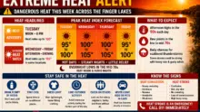
Forecasters say Tuesday is only the opening act. While heat index values are expected to climb into the upper 90s this afternoon, conditions are forecast to become even more oppressive Wednesday and Thursday, when much of the region could flirt with 105-degree heat index values. An Extreme Heat Watch remains in effect through Friday for much of the Finger Lakes and Central New York, where this could become the hottest weather of the year so far.
The dangerous heat won’t arrive quietly. A warm front crossing Upstate New York today could spark scattered thunderstorms, and a few may become severe with damaging wind gusts, large hail, torrential rainfall, and isolated flash flooding before the atmosphere settles into its hottest phase.
Today’s weather
Tuesday begins warm and increasingly humid before conditions become dangerous by early afternoon.
Temperatures will climb into the upper 80s and lower 90s across the Finger Lakes, while dew points surge into the lower 70s. That combination will push “feels-like” temperatures into the upper 90s for much of the region, prompting the National Weather Service’s Heat Advisory from noon until 8 p.m.
Clouds and scattered thunderstorms could develop at almost any point during the day as a warm front slowly pushes east. While not everyone will see rain, any storm that develops will have access to unusually unstable air for late June. The strongest storms could produce damaging wind gusts, hail, dangerous lightning, and brief but intense downpours.
If you have outdoor plans today, especially during the afternoon or evening, stay weather-aware. Conditions can change quickly, and thunderstorms may develop with little warning.
The hottest weather is still ahead
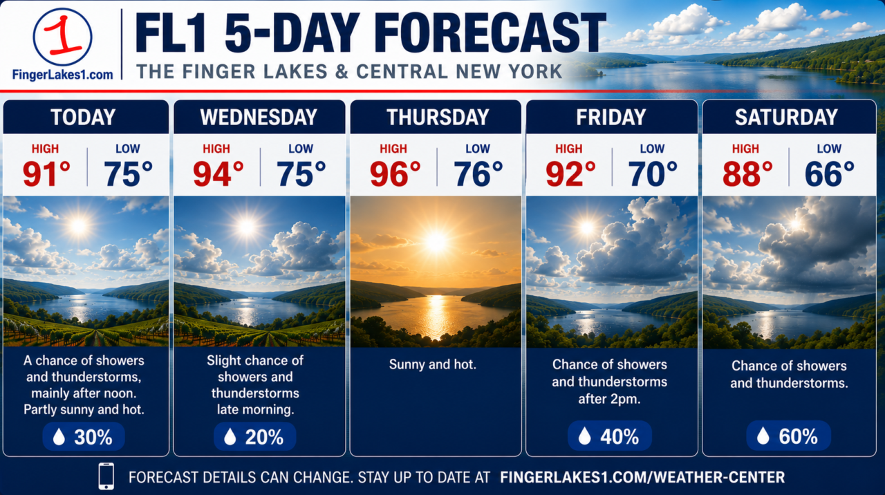
While Tuesday’s heat is dangerous, Wednesday and Thursday are expected to be the peak of this event.
A massive dome of high pressure will strengthen across the eastern United States, trapping hot, humid air over New York. Meteorologists often describe this setup as a “heat dome” because the high-pressure system acts like a lid, preventing cooler air from mixing into the atmosphere while allowing temperatures to build day after day.
Afternoon highs will reach the lower to middle 90s across much of the Finger Lakes, with some traditionally hotter inland valleys potentially approaching the upper 90s. Combined with tropical humidity, heat index values could briefly reach or exceed 105 degrees in some locations.
The nights won’t provide much relief.
Low temperatures will only fall into the lower and middle 70s through Friday morning, making it difficult for homes without air conditioning to cool down. Multiple nights of warm, humid conditions significantly increase the risk of heat-related illness because the body has little opportunity to recover before the next day’s heat returns.
Forecast confidence remains high that this prolonged heat event will occur. The primary uncertainty involves exactly how high temperatures climb each afternoon because scattered thunderstorms and cloud cover may temporarily reduce heating in some communities.

Thunderstorms could interrupt the heat
The Finger Lakes sits along the northern edge of the expanding heat dome, placing the region in a favorable position for clusters of thunderstorms to ride around the ridge.

Today and Wednesday carry the greatest potential for strong to severe storms.
Forecast models indicate the atmosphere will contain exceptional instability, with enough energy to support organized thunderstorms capable of producing damaging winds and large hail. Forecasters are also monitoring the possibility that a larger thunderstorm complex could develop over southern Ontario before diving southeast into New York.
At this point, confidence in exactly where those storms develop remains low. Some forecast models keep the strongest storms north and east of the Finger Lakes, while others bring them directly across Central New York.
Regardless of the exact track, any thunderstorm this week will have the potential to produce torrential rainfall. Because the atmosphere will contain abundant moisture, localized rainfall rates could become intense enough to create isolated flash flooding where storms repeatedly move over the same locations.
Heat safety becomes essential
This week’s weather deserves more than casual attention.
Drink water frequently throughout the day, even if you don’t feel thirsty yet. Limit strenuous outdoor work during the afternoon, wear lightweight and loose-fitting clothing, and spend time in air-conditioned buildings whenever possible.
Know the warning signs of heat exhaustion, including dizziness, heavy sweating, weakness, muscle cramps, nausea, headache, and excessive thirst. If symptoms progress to confusion, hot dry skin, loss of consciousness, or difficulty responding, treat the situation as heat stroke and call 911 immediately.
Never leave children or pets inside a parked vehicle, even for a short time. Vehicle interiors can become deadly within minutes during this type of heat event.
Looking ahead to the holiday weekend
The heat won’t disappear overnight, but there are signs that relief is on the horizon.
Beginning Friday, the upper-level ridge responsible for the dangerous heat should gradually weaken as disturbances move southeast from Canada. That change will increase the chances for showers and thunderstorms while slowly knocking temperatures down a few degrees heading into the Independence Day weekend.
It will still feel like summer. Highs are expected to remain in the 80s with continued humidity, but the most dangerous heat should begin easing after Thursday.
Until then, expect a stretch of weather that will demand attention. Between the dangerous daytime heat, warm nights, and daily opportunities for strong thunderstorms, this will be one of the most active and impactful weather weeks the Finger Lakes has seen so far this summer.
 Louisiana Meteor Fireball Lights Up the Early Morning Sky Across the Southern United States
 FingerLakes1.com is the region’s leading all-digital news publication. The company was founded in 1998 and has been keeping residents informed for more than two decades. Have a lead? Send it to news@fingerlakes1.com.