

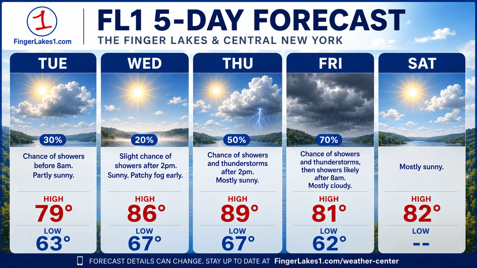
A slow-moving weather system will keep a few showers around the Finger Lakes and Central New York early Tuesday before drier, warmer weather takes over for the middle of the week.

The FL1 5-Day Forecast starts unsettled, but the overall pattern is not a washout. Tuesday will bring lingering clouds and spotty showers, especially across the Southern Tier, western Finger Lakes and parts of Central New York. By Wednesday, high pressure builds in and gives the region a cleaner summer day, with more sun and temperatures climbing back into the 80s.
The next thing to watch is late Thursday into Friday, when another front approaches the eastern Great Lakes. That will bring the best chance of showers and thunderstorms later in the week. The timing still matters, especially Friday, because a later-day frontal passage would give storms more heat and humidity to work with.
Behind that front, the weekend is trending mainly dry and warm, with lower humidity by Saturday.
Today’s weather
Tuesday morning starts with scattered showers rotating across parts of the region, but the coverage will not be even. The best chance for rain will be across the Southern Tier, western Finger Lakes, Central New York and areas near the I-90 corridor early in the day.
Some showers could briefly produce moderate to heavy rain, especially where they move slowly or redevelop over the same locations. The overall flash flood risk remains low, but there could be localized downpours during the morning commute.
By late morning and afternoon, the trend turns drier for most of the Finger Lakes. A few lingering showers or an isolated thunderstorm could still pop up, but coverage should be sparse. Areas farther north and closer to the lake plains should see more dry time.
Clouds will gradually break through the day. Syracuse, Auburn, Geneva and the northern Finger Lakes should have a better shot at partial sunshine earlier in the afternoon, while the Southern Tier and higher terrain may hold onto clouds longer.
Temperatures will reach the 70s in many areas, with low 80s possible around Syracuse and some lower elevations. Winds will stay light, generally out of the east.
Tuesday night turns calmer as weak high pressure builds overhead. Clearing skies, light winds and leftover low-level moisture will make patchy fog likely overnight into early Wednesday. Valley fog could be locally dense in parts of the Southern Tier, western Finger Lakes and river valleys.
Wednesday brings the best weather
Wednesday looks like the cleanest day of the week for outdoor plans.
After early fog burns off, most of the region should see partly to mostly sunny skies and dry weather. High pressure will be in control, and that should limit shower development across the Finger Lakes, Rochester area, Syracuse area, Ithaca, Auburn, Geneva and Canandaigua.
There is a very small chance of a stray late-day shower or thunderstorm near Steuben and Yates counties, but that looks like the exception, not the rule.
Temperatures will climb into the 80s across much of Central New York and the Finger Lakes. Humidity will start to creep upward, but it should not be oppressive for most of the day. By Wednesday night, lows will settle into the 60s, with some patchy fog possible again in the usual valleys.
For anyone trying to mow, get lake time in, work outside or travel, Wednesday is the best bet in the five-day stretch.
Heat and humidity build Thursday
Thursday will feel more like mid-July.
 Ithaca soccer standout picks Marist
 Highs will push into the mid and upper 80s for many lower-elevation locations, with some valleys near 90 degrees. Heat index values could reach the upper 80s to lower 90s in much of the region. Some spots south of Lake Ontario and across the western Finger Lakes could feel a little hotter.
The day should start dry for most areas, but shower and thunderstorm chances will slowly increase later Thursday as the next system approaches from the west.
There is still some uncertainty about how widespread Thursday’s storms become. The setup does not look especially organized during the day. Forcing will be weak, which means any storms may be more scattered and pop-up in nature rather than a broad, steady rain event.
Lake influences may also matter. A southwest breeze could create stable lake shadows northeast of Lake Erie and Lake Ontario, keeping some areas drier than surrounding communities.
Still, anyone with late-day outdoor plans Thursday should keep an eye on radar, especially inland from the lakes.
Friday is the main storm day
Friday has the highest chance for showers and thunderstorms in the five-day forecast.
A weak cold front and upper-level disturbance are expected to move through the eastern Great Lakes and Central New York. Compared with Thursday, the atmosphere should have better lift and more organization. That gives the region a higher probability of showers and storms.
The biggest uncertainty is timing. If the front moves through earlier in the day, severe weather potential would likely stay limited. If it arrives later, storms would have more daytime heating and humidity available. That could allow for more organized thunderstorms, especially across Central New York, the Southern Tier and parts of the Finger Lakes.
At this point, Friday looks more active than Thursday, but not necessarily like a widespread severe weather day. The main concerns would be locally heavy rain, brief gusty winds and lightning with any stronger storms.
Clouds and showers will hold temperatures down compared with Thursday. Highs should range from the upper 70s to mid-80s.
Weekend outlook
The front should clear the region Friday night, setting up a better weekend pattern.
Saturday looks mainly dry, partly to mostly sunny and warm. Highs will reach the upper 70s to mid-80s, but the bigger change will be humidity. Dew points should fall back into a more comfortable range, making Saturday feel noticeably better than Thursday or Friday.
Sunday also looks mostly dry and warm, with highs back in the 80s. There is still a low chance of a few showers or thunderstorms depending on how a disturbance tracks through the Mid-Atlantic, but right now the weekend does not look like a washout.
For the Finger Lakes, Central New York, Rochester, Syracuse, Ithaca, Auburn, Geneva and Canandaigua, the takeaway is simple: get through some leftover showers Tuesday, enjoy Wednesday, watch for pop-up storms Thursday, and pay closer attention to Friday’s front.
After that, the weekend is trending in the right direction.
 Groton runner heading to Geneseo
FingerLakes1.com is the region’s leading all-digital news publication. The company was founded in 1998 and has been keeping residents informed for more than two decades. Have a lead? Send it to news@fingerlakes1.com.