


The National Weather Service has issued a series of urgent weather alerts for the Finger Lakes and Central New York regions, forecasting heavy lake-effect snow and dangerous cold temperatures through midweek. Counties under active alerts include Monroe, Wayne, Cayuga, Ontario, Seneca, Schuyler, Tompkins, Yates, and Onondaga, with conditions expected to vary significantly depending on location.
A Lake Effect Snow Warning remains in effect for Monroe County until 4 p.m. Monday. Persistent lake-effect snow north of Route 104 is projected to add another 4 to 8 inches of accumulation, making travel hazardous, especially during the morning commute. Neighboring Wayne and northern Cayuga counties are under a Winter Weather Advisory until 7 p.m., with similar snowfall accumulations expected.

Travelers should brace for rapid changes in visibility and road conditions as snowbands shift. The National Weather Service cautions drivers to prepare for delays and potential disruptions throughout the region.
Cold temperatures and severe wind chills will deepen the impact of these conditions. Cold Weather Advisories have been issued across the entire region beginning this evening and continuing through Wednesday morning. Wind chills as low as -20°F will create life-threatening risks, such as frostbite in as little as 30 minutes of exposure.
Local residents are advised to take precautions by limiting outdoor activities and wearing appropriate winter clothing. Experts recommend layering, including hats and gloves, to prevent frostbite. Additionally, pets should be kept indoors or provided with adequate shelter during the cold snap.
The most intense lake-effect snow activity is anticipated to continue Monday night into Tuesday, with bands gradually tapering off midweek. While Monroe and Wayne counties are expected to see the heaviest snow, the surrounding areas, including Ontario and Seneca counties, will face significant snowfall, potentially disrupting commutes and public services.
What NWS alerts come along with extreme cold?
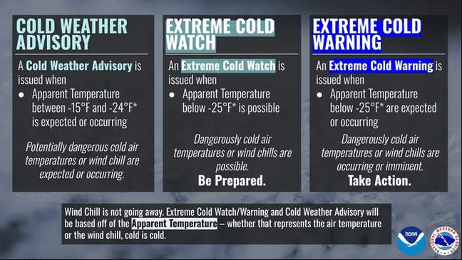
The National Weather Service has redefined its cold weather alerts to enhance public understanding and safety.
An Extreme Cold Watch is issued when dangerously cold air temperatures or wind chill values are possible, advising individuals to prepare for potential exposure. An Extreme Cold Warning indicates that such conditions are expected or occurring, necessitating immediate protective actions to prevent frostbite and hypothermia.
In contrast, a Cold Weather Advisory is issued for seasonably cold temperatures or wind chills that are less severe but still warrant caution, reminding the public to dress appropriately and cover exposed skin when outdoors.
Governor Hochul urges preparation for frigid cold
Governor Kathy Hochul has directed state agencies to prepare for extreme cold and lake effect snow forecasted to hit New York starting Sunday. Temperatures as low as -25°F and heavy snowfall are expected in regions near Lakes Erie and Ontario through midweek, with snow also impacting Long Island and New York City.

State resources, including plows, emergency responders, and utility crews, are on alert. Residents are advised to monitor conditions, avoid unnecessary travel, and follow safety guidelines for heating, power outages, and driving.
For the latest forecast check out the FingerLakes1.com Weather Center.
FingerLakes1.com is the region’s leading all-digital news publication. The company was founded in 1998 and has been keeping residents informed for more than two decades. Have a lead? Send it to [email protected].