

The Finger Lakes moves into its hottest stretch of the week on Tuesday, with a Heat Advisory in effect until 8 p.m. for Cayuga, Ontario, Schuyler, Seneca, Tompkins, Wayne and Yates counties as temperatures climb well into the 90s and heat index values push into the upper 90s and low 100s. National Weather Service forecasters in Buffalo and Binghamton both point to Tuesday as the day with the highest heat risk across the region, especially away from the immediate lake influence and in the warmer valleys from Ontario County through Tompkins and Schuyler counties.
For most communities from Auburn and Newark to Geneva, Penn Yan, Watkins Glen and Ithaca, the forecast is mostly sunny, hot and breezy rather than stormy, with southwest wind gusts commonly reaching 25 to 35 mph this afternoon. A plume of haze and wildfire smoke from Canada may become more noticeable later today and especially Wednesday, but the stronger and more certain message for now is that this is a heat-driven forecast first, with the sharpest relief not arriving until a cold front drops through on Wednesday.

Today’s weather
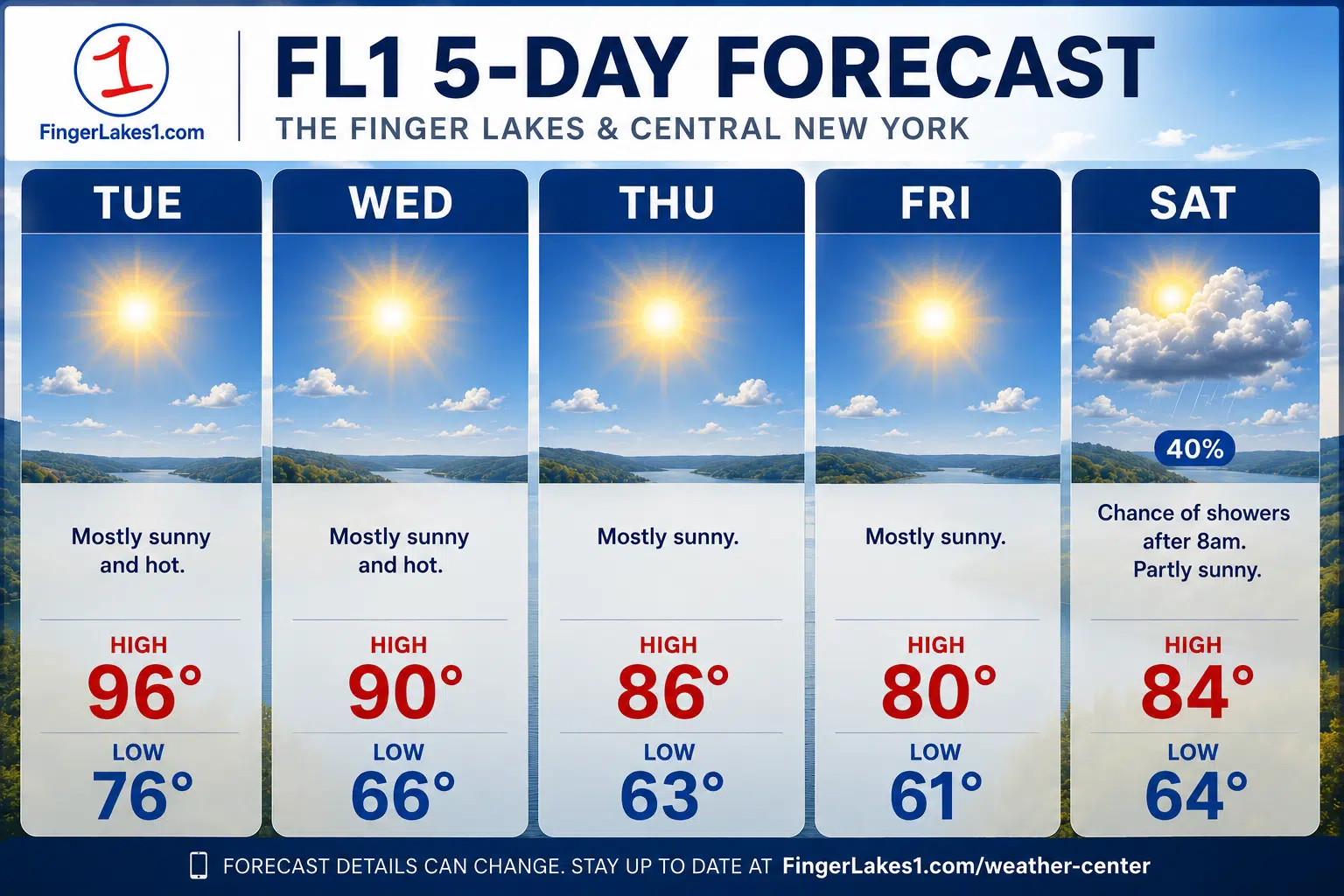
The day starts warm and does not offer much of a ramp-up period before the heat becomes noticeable. Overnight lows only fall into the upper 60s and 70s across much of the region, and official NWS point forecasts then drive highs to about 95 in Penn Yan, 96 in Auburn, 98 in Geneva, Ithaca and Lyons, and the lower to middle 90s in many surrounding communities.
That means the midday-to-early-evening window is the one to watch most closely for the Finger Lakes. The combination of very warm air, dew points in the mid to upper 60s and persistent sun should make it feel hotter than the air temperature in many spots, with the most uncomfortable conditions likely in inland valley areas and built-up communities where shade and airflow are limited.
This is not shaping up like a day where thunderstorms break the heat for most of the Finger Lakes. The broader forecast from both NWS offices keeps the region largely dry through Tuesday, so there is little sign of a widespread afternoon interruption for outdoor work, lake plans, travel or youth sports. The tradeoff is that the heat has more room to fully build.
Heat, wind and smoke concerns
The wind will be noticeable, and in some places it may keep the air from feeling completely stagnant, but it will not erase the heat risk. Buffalo forecasters expect a strengthening low-level jet to help mix down frequent southwest gusts, and that matters for communities along open terrain, east-west roads and the larger lakes where the breeze could be strong enough to affect boating conditions and make the afternoon feel harsher rather than gentler.
For residents, crews and organizers across Cayuga, Seneca, Ontario, Wayne, Yates, Schuyler and Tompkins counties, the practical concern is duration. Several straight hours of temperatures in the 90s, followed by only a warm Tuesday night in the middle to upper 70s, can leave homes, pavement, vehicles and work sites slow to cool off. The usual midsummer steps matter most on a day like this: water, shade, slower pacing for outdoor labor and extra attention to children, older adults and anyone spending a long stretch outside.
Smoke is the forecast wrinkle that still carries more uncertainty than the heat itself. Binghamton added haze and smoke to its forecast grids because flow from active fires in south-central Canada is expected to send smoke into the Northeast, and forecasters there said some of that smoke could limit heating a bit today before potentially becoming thicker on Wednesday. At ground level, that means some Finger Lakes communities may notice a milkier sky or reduced visibility at times, but the exact density and how far south and west the thickest smoke reaches remain less certain than the heat forecast.
Midweek changes
Wednesday is still a warm day, but it should not behave exactly like Tuesday. A cold front is expected to sag south through the region during the day, knocking humidity down from north to south and gradually replacing the sticky air with a drier feel by later afternoon and evening.
The timing of that change matters across the region. Wayne, Cayuga and northern Ontario County stand to feel the less humid air first, while Schuyler and Tompkins counties could hold onto the more uncomfortable air longer into the day. Official point forecasts still keep highs around 90 to 93 in many communities Wednesday, so this is more of a moderation than a true cooldown, but it should become more manageable as the day goes on.
Smoke may become a bigger part of the Wednesday forecast even while the humidity eases. Binghamton forecasters warned that some of the wildfire smoke could move closer to the surface behind the front, and aviation forecasts already flag the possibility of visibility restrictions at times. That does not guarantee a regionwide smoky day, but it does mean the clearest weather story Wednesday may be a mixed one: somewhat less oppressive heat, but potentially murkier skies.
Five-day outlook
Thursday currently looks like the most usable all-around day in the near-term stretch for the Finger Lakes. Temperatures stay above normal, generally in the upper 80s, but dew points are expected to be lower and both Buffalo and Binghamton point to a drier pattern after the front. If the smoke plume thins enough, Thursday should offer the best combination of warmth and lower humidity for field work, errands and outdoor plans.
Friday still leans mostly dry for much of the day, especially early, with highs around the lower 80s north and west of the lakes and the middle 80s farther south toward Ithaca and the Southern Tier edge. The first hint of a forecast change appears late, when point forecasts for parts of the Finger Lakes begin introducing a slight chance of showers or thunderstorms, especially west and south of the lakes.
Saturday carries the broader signal for more unsettled weather. Binghamton sees a better chance for more widespread showers and thunderstorms over the weekend as the larger heat ridge shifts west and a trough digs into the Northeast, while Buffalo also turns Friday into Saturday away from the fully dry pattern. At this distance, that does not support calling for a washout, but it does support keeping weekend plans flexible and watching later forecasts for timing and any stronger storm potential.

FingerLakes1.com is the region’s leading all-digital news publication. The company was founded in 1998 and has been keeping residents informed for more than two decades. Have a lead? Send it to news@fingerlakes1.com.