

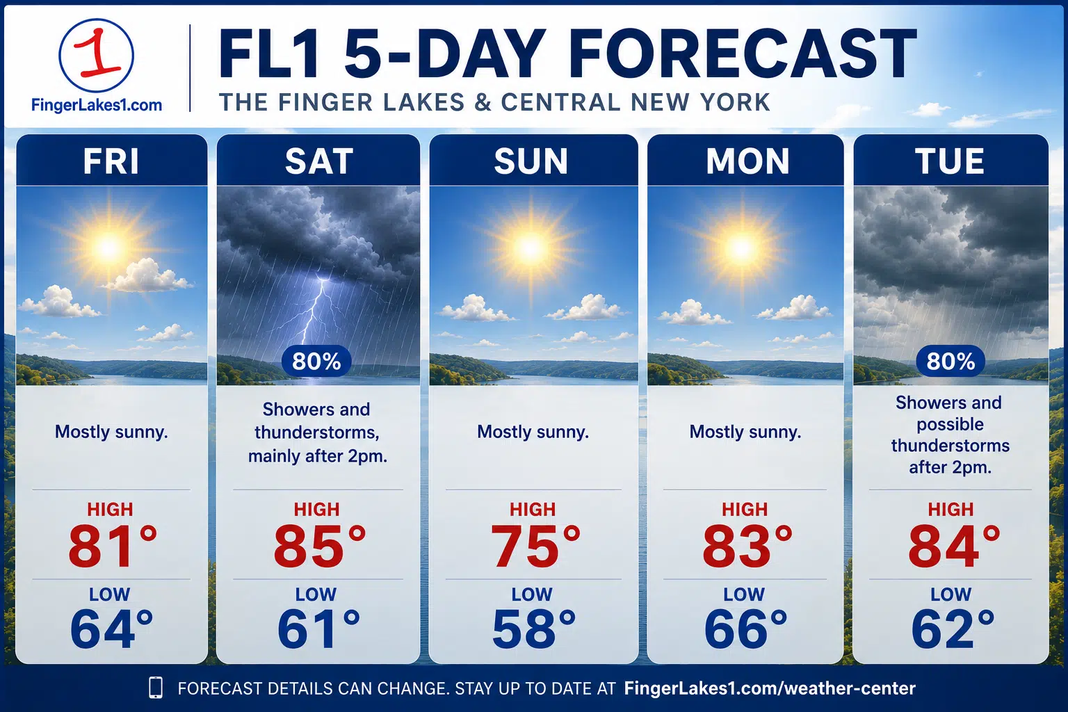
Wildfire smoke will continue to shape Friday across the Finger Lakes and Central New York, but forecasters say the haze should gradually thin and shift southwest before a stronger weather system brings the region’s next widespread round of showers and thunderstorms on Saturday.
The latest forecast discussions from the National Weather Service offices in Buffalo and Binghamton point to a quieter stretch for most of Friday beyond the smoke, then a more active weekend setup with some storms that could turn strong, locally heavy rain, and a return to cleaner air behind the system by Sunday.

Smoke lingers through Friday
The forecast entering Friday still starts with smoke, not rain, as the main regional weather issue. Buffalo forecasters said smoke from active wildfires in south-central Canada will continue to affect western and north-central New York through the day, while Binghamton said near-surface smoke should remain present into Friday before pushing farther southwest and thinning out for at least part of Central New York and the western Catskills.
That split matters across the broader Finger Lakes and Central New York corridor because conditions may improve sooner from Syracuse north and east than they do farther south and west. Binghamton’s discussion said the western and central Southern Tier, along with parts of northeast Pennsylvania, could stay closer to the thicker edge of the plume, while Buffalo said smoke near the surface should drift back toward the Genesee Valley later Friday after easing from north to south overnight.
Neither office described Friday as a washout or a major storm day. The signal instead is for a mostly dry day with hazy skies, changing visibility, and enough uncertainty in the smoke coverage to affect how bright and how warm the afternoon feels from one community to the next.
Buffalo also noted that smoke near the surface could be accompanied at times by visibility in the MVFR to IFR range, especially early, and its watch-and-advisory section kept air quality alerts posted for parts of western New York into Friday night. In the Binghamton forecast area, the office said the more substantial air quality alert remains centered on northeast Pennsylvania, but its discussion still expects smoke to lift back into all areas on Saturday ahead of the next system.
Showers and thunderstorms build late Friday night and Saturday
The cleaner break in the weather does not last long. Both forecast offices now line up on Friday night into Saturday as the period when a more organized system pushes into New York, first with a warm front and then with a cold front that should trigger a broader round of showers and thunderstorms.
Buffalo said showers and a few thunderstorms will move in late Friday night into Saturday morning as the warm front lifts through, followed by more widespread showers and storms along and ahead of the cold front Saturday afternoon and evening. Binghamton described a similar sequence, with scattered showers and thunderstorms possible in the morning before the atmosphere destabilizes further during the afternoon.
That timing makes Saturday the most unsettled part of the five-day stretch. It also means the day may not be uniformly wet from start to finish. The stronger signal is for multiple rounds or periods of showers and thunderstorms rather than a steady, all-day rain, with the higher coverage arriving as the afternoon and evening frontal passage draws closer.
Stronger storms and heavy rain remain limited but real concerns
Forecasters are also drawing a clearer line around the main hazards for Saturday without overselling them. Buffalo said increasing instability and modest wind fields may support a few strong to severe thunderstorms, while Binghamton said some storms may become severe primarily west of Interstate 81, where the best combination of instability and wind shear is expected to set up.

Binghamton’s discussion said the latest Storm Prediction Center outlook keeps much of the region in a Marginal Risk, with a Slight Risk introduced for the central Southern Tier, western Finger Lakes and nearby parts of northeast Pennsylvania. That does not point to a widespread severe outbreak, but it does support closer attention to storm organization Saturday afternoon, especially from the western Finger Lakes south toward Steuben and Chemung counties.
The rain signal also carries some nuance. Binghamton said the atmosphere will be unusually moist for mid-July, with precipitable water values rising to around 2 inches, and it noted a marginal excessive rainfall outlook focused mainly on urban drainage trouble spots and smaller storm-drain networks. At the same time, the office emphasized that much of the rural area has been relatively dry, which should limit broader flash-flood concerns unless heavier rain rates persist over the same place for a longer stretch.
That matches the broader weekend picture in Buffalo’s discussion, which highlighted thunderstorm chances through Saturday until the cold front passes but did not frame the event as a prolonged flooding setup. For the Finger Lakes and Central New York as a whole, the present forecast supports a more targeted concern for brief downpours, gusty winds and lightning in stronger storms than for regionwide high-impact flooding.
Sunday turns quieter and next week stays seasonable
Once the weekend system moves through, both forecast offices expect the air mass to improve. Buffalo said a continued west-southwest flow should mostly eliminate the smoke this weekend, and Binghamton said the expected weather activity on Saturday should disrupt the plume and move it out of the region for Sunday.
That leaves Sunday as the transition back toward fairer weather, with high pressure building in from the west and a quieter pattern expected through at least part of Monday. Buffalo’s aviation outlook calls for fair weather Sunday and Monday, and Binghamton likewise said high pressure should settle in through Monday after the weekend system exits.
The forecast does not stay locked in for long after that. Binghamton said unsettled weather returns Tuesday as another frontal system sweeps across the region with the potential for showers, thunderstorms and locally heavy rain again, while Buffalo also points to renewed restrictions in periodic showers and thunderstorms by Monday night and Tuesday.
Temperatures through next week are expected to run near average rather than sharply hotter. Binghamton said readings should stay near or even slightly below normal for much of the period, a notable shift from the hotter midsummer pattern that often follows a July cold front. By the middle of next week, northwest flow could also allow wildfire smoke to return toward the region again, though that part of the forecast remains less certain than the weekend storm signal.
For now, the clearest progression in the forecast is a hazy but mostly quieter Friday, a more active Saturday with the weekend’s best chance for thunderstorms and localized heavier rain, then a cleaner and calmer turn for Sunday before the next round of unsettled weather tries to organize during the middle of next week.
Check the latest forecast at the FingerLakes1.com Weather Center.


FingerLakes1.com is the region’s leading all-digital news publication. The company was founded in 1998 and has been keeping residents informed for more than two decades. Have a lead? Send it to news@fingerlakes1.com.