


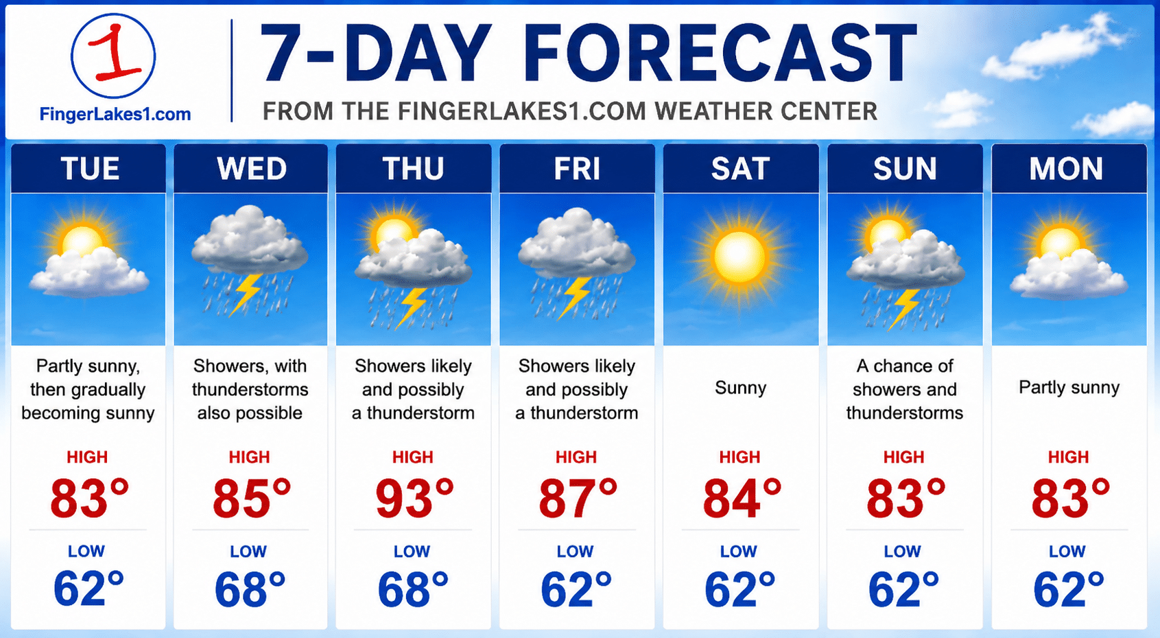
A stretch of warm, pleasant weather will give way to summer heat and increasing humidity across the Finger Lakes this week, with temperatures potentially climbing into the 90s before rounds of showers and thunderstorms arrive.

Forecasters with the National Weather Service offices in Buffalo and Binghamton say high pressure will keep conditions quiet through Tuesday, but a shift to a south-southwest flow will steadily pump warmer air into the region. While Monday will feature highs in the upper 70s to low 80s, temperatures are expected to climb into the mid and upper 80s Tuesday, with some valleys and lower-elevation communities reaching 90 degrees or higher by Thursday.

Pleasant start gives way to summer heat

The first half of the week should provide plenty of sunshine and comfortable weather before humidity becomes a bigger factor. Overnight lows will also trend upward, with many communities seeing temperatures remain in the mid to upper 60s by the end of the week.
Heat index values could reach the mid-90s in some parts of the Finger Lakes late in the week, particularly away from the lakeshores, where cooler lake breezes may keep temperatures slightly lower. If the warmer forecast holds, heat advisories could become a possibility.
Storm chances increase by midweek
Dry weather is expected to hold through Tuesday before a weak warm front and an approaching upper-level disturbance bring the first chances for scattered showers and thunderstorms on Wednesday.
Storm coverage may briefly decrease Thursday, but another weather system and an approaching cold front are expected to bring additional rounds of showers and thunderstorms Friday and into Saturday. Some isolated activity could linger into Sunday if the front stalls over the region.

Heavy rain may be the biggest concern
At this point, forecasters say heavy rainfall appears to be the primary threat from any storms that develop later this week. Atmospheric moisture levels are expected to be unusually high for early June, creating the potential for downpours.
The risk for severe thunderstorms remains more uncertain because it is still too early to know whether enough wind shear and instability will come together at the same time. While a few stronger storms cannot be ruled out, confidence is higher that localized heavy rain will be the more widespread impact.
What to expect day by day
Monday and Tuesday should be the best days for outdoor plans, with mainly sunny skies and warming temperatures. Wednesday brings the return of scattered showers and thunderstorms, followed by a hot and humid stretch Thursday and Friday with additional opportunities for storms.
Heading into the weekend, conditions are expected to remain unsettled before drier air gradually works back into the Finger Lakes, potentially bringing an improvement by the start of next week.


FingerLakes1.com is the region’s leading all-digital news publication. The company was founded in 1998 and has been keeping residents informed for more than two decades. Have a lead? Send it to news@fingerlakes1.com.