

A tropical disturbance in the Gulf of Mexico is tracking toward the northern Gulf Coast, with forecasters warning that it could develop into a tropical depression before making landfall later this week.
The system is already impacting weather patterns in Louisiana, Mississippi, Alabama, and the Florida Panhandle, bringing welcome relief from extreme heat but also raising concerns about localized flooding and coastal surge.
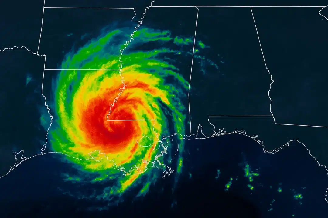
Development Chances Increase as System Moves North
According to the National Hurricane Center, the broad low-pressure system has a 40% chance of developing into a tropical depression over the next 48 hours. While not expected to become a named storm, the system is already producing clusters of showers and thunderstorms that could intensify.
Meteorologists are closely monitoring the disturbance’s movement and structure, as it interacts with warm Gulf waters and favorable atmospheric conditions. If it consolidates, the system could generate strong winds and heavy rainfall in areas already saturated from recent storms.
Where and When Will It Hit?
The center of the disturbance is forecast to drift northwestward, likely making landfall somewhere between southeastern Louisiana and coastal Mississippi by late Thursday or early Friday.
- New Orleans: Flash flooding concerns are increasing, with the National Weather Service warning of 2–4 inches of rain through the weekend.
- Biloxi & Gulfport: South Mississippi could see the heaviest rain bands and minor coastal flooding. Some areas may experience temporary road closures and surge-related impacts near beaches and low-lying zones.
- Florida Panhandle: Scattered downpours are expected, but impacts are likely to be less severe than further west.
Cooler Temperatures—but At a Cost
While residents are bracing for potential flooding, many are also relieved to see a break from relentless triple-digit heat indexes that have gripped the region for much of July. In parts of Mississippi and Alabama, daytime highs are expected to drop by 5 to 10 degrees as tropical moisture and cloud cover blanket the region.
“It’s a trade-off,” said WLOX Chief Meteorologist Wesley Williams. “Yes, the rain could cause problems, but we’re finally getting some real relief from this oppressive heat.”
Key Impacts to Watch
🌧️ Rainfall & Flash Flooding
- 2–4 inches widespread, with localized totals exceeding 6 inches
- Flood-prone urban areas at high risk
- Watch for alerts from the National Weather Service
🌊 Minor Storm Surge
- Especially along south-facing coasts of Louisiana and Mississippi
- Tides 1–2 feet above normal possible in surge-prone zones
🌬️ Gusty Winds
- Not expected to exceed tropical storm strength
- Could knock down tree limbs or cause isolated power outages
What’s Next?
Even if the disturbance doesn’t reach tropical depression strength, the impacts will be felt across much of the Gulf Coast. Emergency officials are urging residents to monitor updates and prepare for sudden downpours, especially in flood-prone neighborhoods.
The system serves as a reminder that the heart of hurricane season is approaching. With peak activity typically arriving in August and September, forecasters warn that similar disturbances could become more frequent—and potentially more intense.
MORE: Local forecast and live radar at our Weather Center
This content is brought to you by the FingerLakes1.com Team. Support our mission by visiting www.patreon.com/fl1 or learn how you send us your local content here.