

The National Weather Service has issued wind and winter weather alerts for a big chunk of the region. If you’re traveling through Sunday evening, check the latest forecast information before hitting the road. We will have the latest updates from the National Weather Service in this post, as well as helpful links to power outage lists by power providers in the region.
Saturday PM Update
Whiteout conditions, damaging winds, a postponed Buffalo Bills game, and even thundersnow. That’s what Western New York has been dealing with this afternoon, as wind gusts in excess of 60 mph have been reported consistently since the late-morning hours.
For those of us here in the Finger Lakes region, the weather isn’t quite as dramatic.
Across our area – snow won’t be an issue. In fact, most should see little or no accumulation. The biggest weather threat will be wind gusts, which could knock power out.
As of 6 p.m. outage reports are significantly less than what we saw from last week’s storm. A few hundred were without power in Cayuga and Steuben counties, with single digit outages in the remainder of the area.
Wind gusts will peak this evening, and then subside overnight as the high wind warning expires before sunrise.
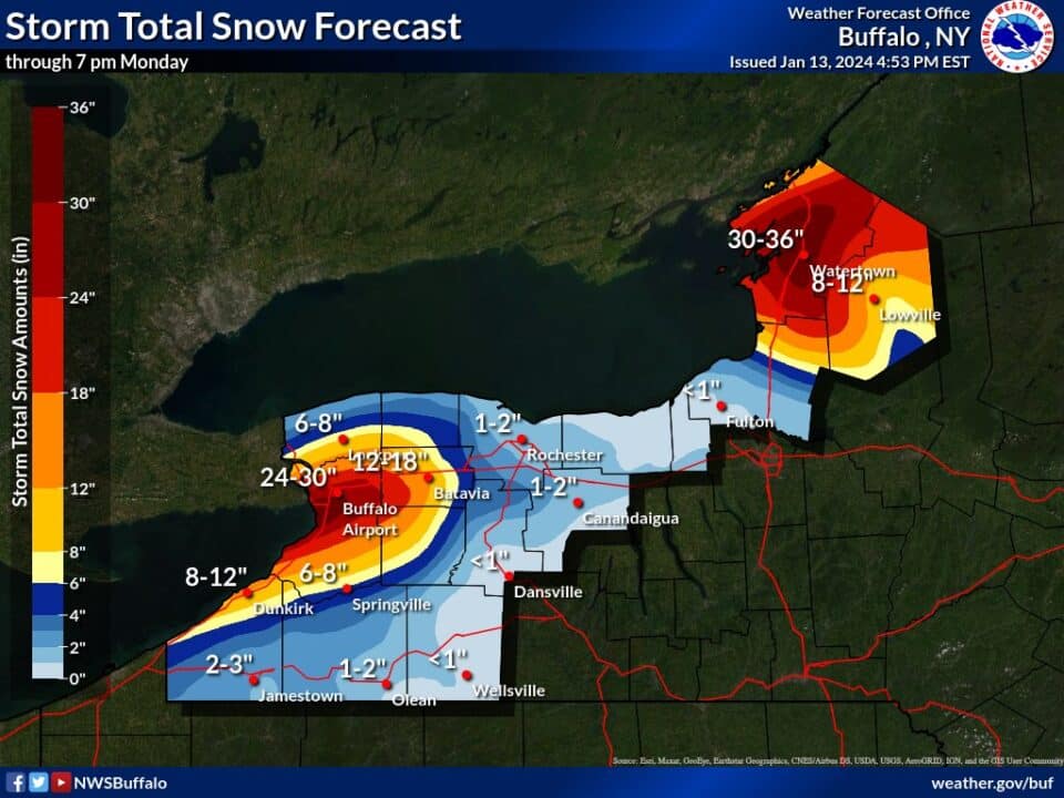
Lake effect snow will be the major headline on Sunday. Areas north of Syracuse and west of Rochester are going to see significant snowfall. If you’re headed toward Buffalo for the Bills game, plan accordingly as more than a foot of snow is expected. Travel will be difficult or downright impossible on the Thruway west of Exit 47. We’ll have more on this as it gets closer.
Local Weather Resources
- NWS Active Alerts
- NYSEG Outage List
- RG&E Outage List
- National Grid Outage List
- Thruway Travel Conditions
- FL1 Weather Center
High Wind Warning
This alert is active for Ontario, Livingston, Monroe, Wayne, and Northern Cayuga counties. All points west of this area are also included. It doesn’t expire until Sunday at 4 a.m. The National Weather Service says southeast winds will be sustained between 25 and 35 mph to begin tonight, then shift to southwest tomorrow morning for the duration. Wind gusts could exceed 60-65 mph throughout.
“People should avoid being outside in forecasted areas and around trees and branches,” the National Weather Service wrote. They added that in the warned areas trees and power lines are expected to come down, and widespread power outages are also likely.
Travel will also be difficult for high-profile vehicles.
Wind Advisory
This alert is active for Cayuga, Seneca, Schuyler, Steuben, Tompkins, and Yates counties. The strongest winds will be in the higher terrain. There will likely be a brief lull in the gusty winds early this morning, before winds pick up again late morning, afternoon and into the evening hours. The advisory remains active through midnight.
Graphics & Media

FingerLakes1.com is the region’s leading all-digital news publication. The company was founded in 1998 and has been keeping residents informed for more than two decades. Have a lead? Send it to [email protected].