


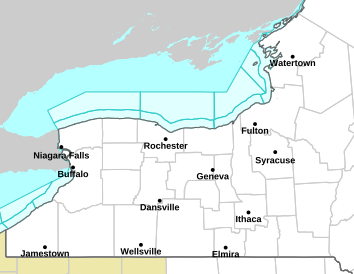
The National Weather Service has issued a Flood Watch for the Finger Lakes region, including several counties in the region. The watch will be in effect from Tuesday through Thursday.
Key threats this week with melting and rainfall
- Rapid Snowmelt: A significant warming trend will push temperatures into the 50s on Tuesday and Wednesday, causing a fast melt-off of the snowpack across the region.
- Heavy Rainfall: A storm system moving from the central plains is expected to bring a general half-inch of rain to the Finger Lakes.
- Ice Jam Concerns: With streams and rivers already partially frozen, ice jams may develop, leading to localized flooding in low-lying areas and along creeks and tributaries.

A look at the timing
- Tuesday Afternoon: Temperatures climb into the low to mid-50s, accelerating snowmelt. Streams and creeks will begin rising.
- Tuesday Night: Rain showers move into the region, further adding to runoff.
- Wednesday: The warmest day of the week, with highs in the upper 50s. Rainfall will be steady, causing streams and rivers to crest.
- Thursday: A strong cold front will move in, dropping temperatures and transitioning rain to snow.
Flooding may occur in creeks, streams, and flood-prone areas. Areas with a history of ice jam flooding should remain especially alert.
What to watch for
- Monitor Flood Warnings: Be ready for updates from the NWS and local officials.
- Avoid Flooded Roads: Never attempt to drive through standing water.
- Secure Property: If you live in a flood-prone area, move valuables to higher ground.
- Check Sump Pumps: Ensure your basement or crawl space is protected from potential flooding.
Long-range calls for a return to cold
While temperatures will remain unseasonably warm through midweek, colder air will return Thursday night into Friday. Snow showers may develop across the region, bringing a return to more typical early March conditions.
For the latest weather updates, check out the FingerLakes1.com Weather Center.

FingerLakes1.com is the region’s leading all-digital news publication. The company was founded in 1998 and has been keeping residents informed for more than two decades. Have a lead? Send it to news@fingerlakes1.com.